
Pīpīwai TrailOn the trail
Makahiku Falls
Last checked 2026-08-16
NPS public domain, Short Hike to Makahiku Falls
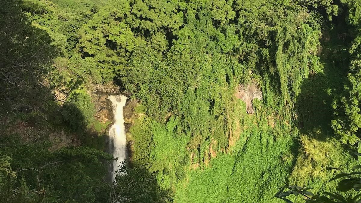
Makahiku Falls is nearly 200 foot drop (61 m) at 0.5 miles, the first waterfall on the Pīpīwai Trail and the first place worth stopping. You see it from a railed clearing across the gulch, about 20 minutes from the trailhead. Turning around here is a real plan: 1 mile round trip in roughly 1 hour. Two things nobody tells you are that the view is often partly screened by foliage, and that in a dry month the falls can be down to a trickle.
| If you stop here | What you get |
|---|---|
| Distance | 0.5 miles from the trailhead |
| Height of the falls | nearly 200 foot (61 m) |
| Climb to get there | 400 ft, half the day's total |
| Time each way | About 30 minutes |
| Round trip | 1 mile, about 1 hour |
| If you continue | 1.5 miles more to Waimoku, 4 miles total |
Where this sits on Pīpīwai
- 1
On this page
Makahiku Overlook
0.5 mi · First waterfall view
- 2
~1 mi · Boardwalks and footbridges
- 3
2 mi one way · 400 ft falls
How far is Makahiku Falls and how tall is it?
0.5 miles from the trailhead, and nearly 200 foot tall, which is 61 metres. Getting there takes about 30 minutes and costs you 400 feet of climb, which is half of the 800 feet the whole trail asks for. That is worth knowing: the hardest part of the Pīpīwai Trail is behind you by the time you reach this overlook.
The route is simple. From the lot, take the trail across from the visitor center, go left at the fork by Hale Hālāwai 0.1 miles in, and climb. The stretch from 0.3 miles is the steepest sustained pitch of the day, cut stone steps set into the hillside in uneven runs, some of them mossy. Then the grade backs off and the overlook appears on your right.
What does the overlook actually look like?
A railed dirt clearing on the edge of the gulch, looking across at the falls rather than up at them. It is a good stop and an honest description of it is that the angle is not the best one on this waterfall. You are roughly level with the middle of the drop, off to one side, at a distance, and the top of the fall is often partly screened by the trees growing out of the gulch wall in front of you.
Which is fine, and nobody says it, so here it is plainly. What you get is a tall thin ribbon of white in a very green cleft, the sound of it coming up at you from below, and often a rainbow in the spray in the middle of the morning. What you do not get is the base of the falls, or an unobstructed full-height view, or anywhere to walk closer. The railing is where the view is. Photographs of this waterfall taken from level with its lip were taken by people on the wrong side of a fence.
Give it five minutes rather than one. The screening moves as you shift along the railing and there is usually one spot where the whole drop opens up.
Is Makahiku a good place to turn around?
Yes, and it is the best turnaround on the trail. Stopping here means you walked 1 mile, climbed 400 feet, saw a 200 foot waterfall, and were out for about 1 hour. That is a real destination rather than a failed attempt at a longer one, and the park publishes it as a short hike in its own right.
Take it if you are driving the Hāna Highway on a schedule and arrived later than you meant to, if anyone in the group found the stone steps harder than expected, if the weather is closing in, or if you have small children who are already done. Take it if it is past four in the afternoon, because the parking lot gates at 5pm.
Keep going if the group is moving well and you have two and a half hours of daylight left. Everything the trail is famous for is past this point: the banyan at 0.7 miles, the bridge, and the bamboo from 1 mile. The climbing does not get worse than what you just did, apart from one short pitch above the bridge, and the grade eases considerably from the banyan onward.
Will Makahiku Falls be running when I get there?
Probably, but not always, and this is the thing every other page leaves out. Makahiku drains a smaller catchment than Waimoku and it responds faster to a dry spell. Through Jul, Aug, Sep it can be down to a trickle threading the rock, and in a genuinely dry stretch the main course can disappear entirely and leave you looking at a wet stain on a cliff.
The strong months are Jan, Feb, Mar, Dec, when it runs wide and loud and the spray comes up to the railing. Apr, Nov are reliable without the mud. If the falls are the entire reason for your walk and you are here in high summer, ask at the visitor center before you start, because the staff know what the stream did last week.
The consolation is that a dry month is a better month to walk this trail. Less mud, better footing on the boardwalk, and the gulch itself is worth the half mile whether or not the water is performing.
What about the pool at the top of the falls?
There is a fenced pool at the lip of Makahiku, and it is the source of most of the dramatic photographs you have seen of this waterfall. People climb the fence to sit in it. They are on wet rounded rock at the top of a 200 foot drop with nothing to hold if they slide, and above a pool whose outflow goes over the edge.
The fence is there because of that, not because the park dislikes photographs. Crossing it is a citable offence and rangers do write the citations. There is no version of this where the picture is worth it, and the overlook view from behind the railing is the one the trail was built to give you.
Is Makahiku the same waterfall as Waimoku?
No, and the two get confused constantly because both are called "the falls on Pīpīwai." Makahiku is 200 feet, at 0.5 miles, seen across a gulch from a railed clearing. Waimoku is 400 feet, at 2 miles, seen from a boulder field directly beneath it at the end of the trail.
If a page quotes a single height for "the waterfall on the Pīpīwai Trail," it is one of those two numbers and the difference is a mile and a half of walking. Makahiku is the one you can reach in half an hour. Waimoku is the one in the postcards.
Questions
- How far is Makahiku Falls on the Pipiwai Trail?
- 0.5 miles from the trailhead, about 30 minutes of walking and 400 feet of climb.
- How tall is Makahiku Falls?
- nearly 200 foot, or 61 metres. The 400 foot figure you may have seen belongs to Waimoku Falls at the end of the same trail.
- Can you hike to just Makahiku Falls and turn around?
- Yes. That is a 1 mile round trip in about 1 hour, and it gets you past the steepest climbing on the trail.
- Is Makahiku Falls the same as Waimoku Falls?
- No. Makahiku is 200 feet at 0.5 miles. Waimoku is 400 feet at 2 miles. Both get called the falls on Pīpīwai.
- Can you swim at Makahiku Falls?
- No. There is no trail access to the base, and the fenced pool at the lip is a citable offence to enter and sits at the top of a 200 foot drop.
- Is Makahiku Falls ever dry?
- It can drop to a trickle through Jul, Aug, Sep, and in a long dry spell the main course can vanish. Jan, Feb, Mar, Dec are the strong months.
Sources: https://www.nps.gov/thingstodo/short-hike-to-makahiku-falls.htm · https://www.nps.gov/hale/planyourvisit/hiking.htm · https://www.nps.gov/hale/planyourvisit/kipahulu.htm · https://en.wikipedia.org/wiki/Makahiku_Falls